


Land Calculator
Area, Length
Description of Land Calculator: Area, Length
Land Calculator is a versatile application designed for the Android platform that provides a comprehensive set of tools for measuring land area and perimeter. This app is beneficial for a variety of users, including farmers, engineers, real estate agents, and GIS professionals. With its user-friendly interface, individuals can easily download Land Calculator to start utilizing its capabilities for field measurements and surveys.
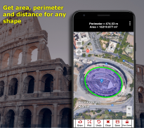
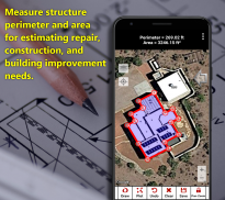
The primary function of Land Calculator is to allow users to measure the area and perimeter of any land shape. Unlike many traditional tools that restrict measurements to straight lines, this app enables the creation of more complex shapes by combining points and curves. This feature results in more accurate calculations, making it an essential tool for those who require precise measurements for their land.
Users can create field surveys by drawing any shape on a map, which provides the enclosed area and perimeter of that shape. This flexibility in drawing shapes is particularly useful for professions that require detailed mapping, such as land surveying and agriculture. The app supports various shapes, accommodating the unique needs of different users.
In addition to drawing shapes, Land Calculator offers the capability to measure land area and perimeter by walking or driving around the perimeter of a field. This feature is particularly helpful for farmers who may need to measure larger plots of land without having to rely solely on traditional measuring tools. By walking or driving, users can gather real-time data, which enhances the accuracy of their measurements.
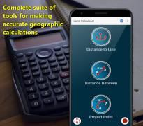
Another valuable tool within the app is the point-to-point distance measurement feature. Users can easily calculate distances between specific points using various map and survey tools. This function is particularly beneficial for planning purposes, such as determining the distance between two points on a property or evaluating the layout of a land parcel.
Land Calculator also includes an area and perimeter unit conversion tool, enabling users to easily switch between different measurement units. This feature simplifies the process of comparing measurements in various formats, which can be crucial for professionals working in different regions or needing to adhere to specific measurement standards.
For those who require precise navigation, the app is equipped with a GPS-controlled compass and GPS reporting capabilities. These tools assist users during field surveys, ensuring that they can accurately locate points and draw shapes in real-time. The integration of GPS technology enhances the overall functionality of the app, enabling users to work efficiently in the field.
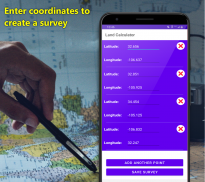
The app supports a selection of coordinate systems, including WGS 84, British Ordnance Survey (OSG36 Datum), ANS, NAD 27, ED 50, and NAD 83, among others. This feature allows users to work within the coordinate system that is most relevant to their specific location or requirements, making Land Calculator adaptable for various applications.
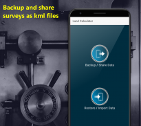
Additionally, Land Calculator includes a backup and restore feature, which allows users to secure their work by backing it up in KML format. This functionality is beneficial for those who may switch devices or need to share their surveys with colleagues. Users can easily import their work into a new device or share it for viewing in Google Earth, enhancing collaboration among team members.
The data generated by this application can also be utilized in ArcGIS, as users can convert their KML files using ArcGIS' KML2Layer feature. Furthermore, the app allows users to convert KML files to DXF format, making it compatible with drawing programs such as AutoCad and SketchUp. This versatility in file formats makes Land Calculator a valuable tool for professionals in various fields, from construction to real estate.
Land Calculator is widely used among farmers for various purposes, including calculating equipment needs, estimating seed requirements, and evaluating water usage and crop value. Real estate agents find the app useful for measuring property size, while insurance agents utilize it for property measurement to assist in adjustments. Property inspectors also rely on the app for accurate measurements needed in mortgage calculations, making it a multi-functional tool across different industries.
For users seeking highly specialized calculations not currently available within the app, there is an option to contact the support team. The developers are open to considering the addition of specialized tools based on user requests, further enhancing the app's capabilities.
With its extensive features and user-friendly design, Land Calculator stands out as a reliable tool for anyone involved in land measurement and surveying. The app's ability to provide accurate measurements for various land shapes, along with its integration of GPS technology and support for multiple coordinate systems, makes it an essential resource for professionals and individuals alike. Download Land Calculator to experience its range of functionalities tailored to meet diverse land measurement needs.
Land Calculator: Area, Length - Version 3.43
(13-11-2022)Land Calculator: Area, Length - APK Information
APK Version: 3.43Package: com.discipleskies.android.landcalculatorLatest Version of Land Calculator: Area, Length
Other versions


Apps in the same category


